top of page


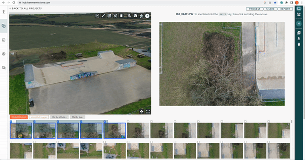
How to Cut and Clean Your 3D Models for Delivery and Presentation in Hammer Missions
Learn how to use Hammer Missions' model clipping tools to clean and present professional 3D drone models — step-by-step guide for building inspections.
Apr 226 min read


What's New in Hammer Missions—January 2026 Product Update
Discover the latest Hub updates: 3D model clipping, improved AI deficiency detection, thermal enhancements, and upcoming Gaussian Splatting.
Feb 22 min read


Advances in 3D Reality Mapping: Gaussian Splatting vs Photogrammetry
Explore gaussian splatting vs photogrammetry, including how each method works, their strengths and limitations, and when to use them in drone-based 3D mapping projects.
Jan 265 min read


How to use Drone 2D Maps and 3D Models in AutoCAD and Revit BIM?
Learn how to turn drone imagery into CAD and BIM outputs for AEC workflows, from capture and processing to AutoCAD and Revit import.
Jan 85 min read


LIDAR vs Photogrammetry: What’s the Difference?
Learn the key differences with LIDAR vs photogrammetry for drone mapping and inspections. Discover how each technology works, their real-world applications, and when to use one over the other for the best results.
Nov 10, 20254 min read


Optimising Drone 3D Mapping: Which Flight Plans Deliver the Best Results?
Learn how different flight plans impact drone 3D mapping quality. Compare single grid, double grid, facade mapping and combined missions for best results.
Oct 28, 20254 min read


What's New in Hammer Missions —September 2025 Product Update
We’ve rolled out major updates to Hammer Hub and the Hammer App to make your drone inspection workflows faster, smarter, and more precise. From improved AI quantification and stronger reporting in Hammer Hub to smarter facade mapping and multi-angle capture in the Hammer App, these features help you deliver higher-quality results with confidence.
Sep 30, 20253 min read


How Accurate is Drone Data?
Learn the difference between relative and absolute accuracy in drone inspections, why GSD matters, and how to get reliable data for engineering projects.
Sep 16, 20254 min read


The Drone Industry Needs More Experts
The drone industry is one of the most unique and fast-evolving industries today. It combines aviation, data science, software, and decision-making into one ecosystem. But here’s the reality: it’s not just about having more experts—it’s about having the right types of experts. For the drone industry to truly thrive, different forms of expertise need to come together. Let’s break down the five essential roles that make a drone operation successful.
Sep 12, 20253 min read


Capturing Buildings with Drones and AI: Strategies, Tips, and Best Practices
Capturing buildings with drones isn’t just about flying — it’s about delivering structured, high-quality data ready for CAD, BIM, and AI workflows. By dividing your captures strategically, collecting both modelling and inspection datasets, using AI effectively, and standardising operations, you can make your building inspections faster, more accurate, and more valuable over time.
Aug 14, 20253 min read


Drone Operations in Cities: Top 10 Best Practices for London and New York
Explore the top 10 best practices for drone operations in built-up areas like London and New York. Learn essential tips on airspace regulations, flight planning, wind management, GPS challenges, and risk mitigation to ensure safe and successful urban drone missions
Aug 11, 20254 min read


How to Inspect a High Rise Building with Drones? A Case Story
Discover how drones and AI are transforming high-rise building inspections—making them faster, safer, and more accurate. This case study from Hammer Missions covers everything from flight planning and 3D modelling to automated defect detection and reporting, helping teams assess building conditions efficiently and with confidence.
Jul 31, 20255 min read


Less is More: Rethinking Data Capture in Drone Facade Inspections
As drones have evolved, so has the scale of data they capture — but more data doesn’t always mean better outcomes. In this article, we explore the rising challenge of over-capture in drone facade inspections and how the industry can shift toward a more efficient, insight-driven approach. From smarter planning to leaner workflows, it’s time to prioritise quality over quantity.
Jul 11, 20254 min read


Drone Photogrammetry Just Got an Upgrade! Introducing Hamlet AI
Introducing Hamlet AI - the latest bolt-on to the Hammer Hub to help streamline your drone photogrammetry projects.
Jan 30, 20242 min read


How to Verify Your Drone Data On-Site? | Hammer Missions
In this article, we look at how to use Hammer Missions to verify your drone data before leaving the job site ensuring high-quality data.
Jun 5, 20232 min read

Captured vs Aligned Images in Drone Photogrammetry: What is it and why does it matter?
In this post, we explain the difference between captured vs aligned drone images in drone photogrammetry.
May 24, 20233 min read


The 6 Types of Drone Data | Hammer Missions
In this post, we explain the 6 types of drone data - everything from raw data all the way to 3D models and actionable PDF reports.
May 5, 20233 min read


The Ultimate Checklist for Drone Mapping | Hammer Missions
In the article, we present the Ultimate Drone Mapping Checklist.
Apr 25, 20235 min read


The Power of 4D Drone Mapping in Construction
The power of 4D Drone Mapping, digital twins and 4D reporting in the construction industry.
Apr 18, 20234 min read


Using 4D Models in Hammer Missions
In this tutorial, we will be looking at how you implement your drone data projects into a 4D models and timeline.
Mar 30, 20233 min read


What can AI offer to the Commercial Drone Industry?
In this post, we will look at the advancements in AI, the future of AI, and how it can change the drone industry as we know it.
Mar 29, 20234 min read
Multi-Selection with Hammer Missions
Select multiple photos with ease as opposed to clicking on individual photos one at a time, process partial datasets.
Mar 2, 20232 min read


Are Building Regulations a call for Drones? | Hammer Missions
In this brief article, we will be looking at the current building regulations and how the use of drone technology can help accelerate change
Feb 21, 20233 min read
What is 4D Drone Mapping and how does it work? | Hammer Missions
In this article, we look at what is 4D Drone data and how drone outputs such as maps and 3D models over time can help build a 4D job site.
Feb 7, 20234 min read
bottom of page