
LIDAR vs Photogrammetry: What’s the Difference?
- Hammer Missions

- Nov 10, 2025
- 4 min read
If you've been involved in the drone or reality mapping world, you've likely come across the terms LIDAR and photogrammetry. But what exactly are they, and when should you use one over the other? In this blog, we’ll break down these technologies, how they work, and their best real-world applications.

What is LIDAR?
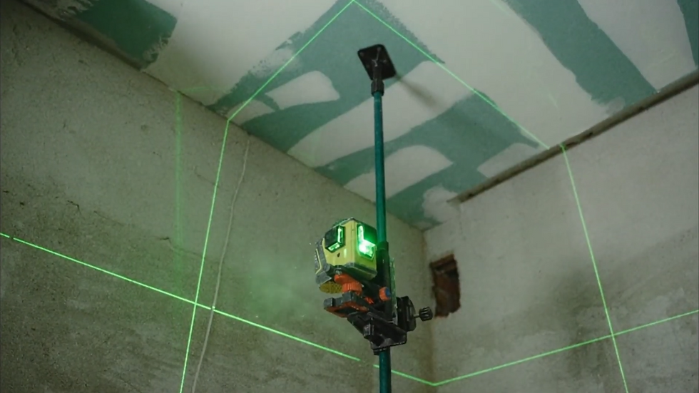
LIDAR (Light Detection and Ranging) is an active sensing method that uses laser scanners to measure distances. Essentially, the scanner emits light pulses, which bounce off surfaces and return to the sensor. By analyzing the time it takes for the light to return, LIDAR creates a highly accurate 3D point cloud of the scanned area or object.
This method is particularly useful when you need centimeter- or even millimeter-level accuracy. LIDAR doesn’t rely on ambient light, so it can work in low-light conditions, under vegetation, or in tunnels. The downside? LIDAR scanners are expensive, often costing tens of thousands of pounds, and the equipment and processing workflows require careful calibration.
What is Photogrammetry?
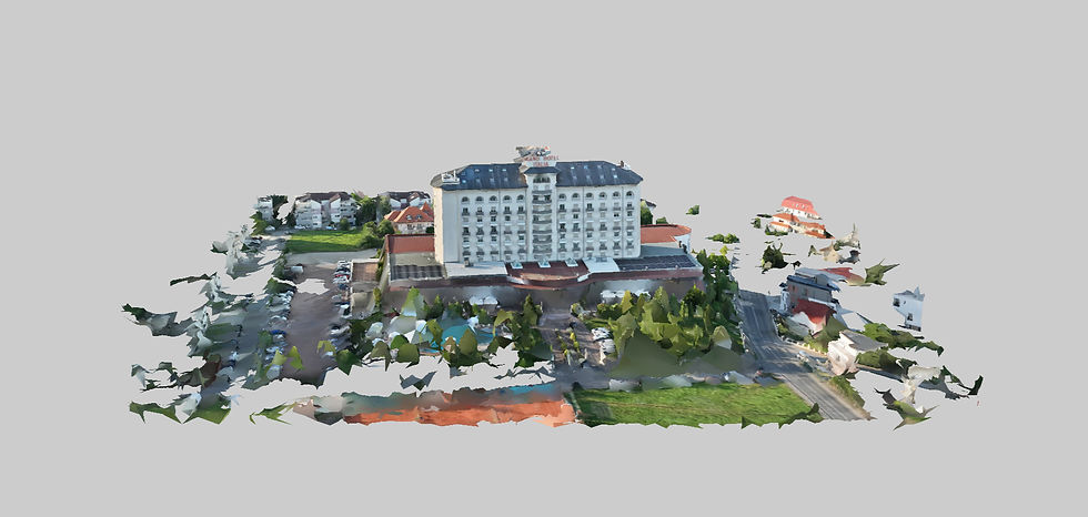
Photogrammetry, on the other hand, is a passive sensing method. It uses overlapping images to reconstruct 3D models based on computer vision. By detecting common features (pixels) between multiple images, photogrammetry software calculates depth and camera positions to generate a 3D representation of the scene.
Today, platforms like Hammer Missions make this process far more accessible — allowing users to plan aerial capture missions, process imagery, and generate high-quality 3D models all within a single workflow.
Unlike LIDAR, photogrammetry captures texture and true color, allowing you to see what objects actually look like. The accuracy depends on factors like the distance to the object, the camera lens, and the quality of the software processing. Typically, photogrammetry can achieve centimeter-level accuracy, which is sufficient for most visual inspection applications.

Key Differences: LIDAR vs Photogrammetry
Feature | LIDAR | Photogrammetry |
Sensing Type | Active (laser-based) | Passive (image-based) |
Data Output | Highly accurate 3D point cloud | Textured 3D model |
Color & Texture | Minimal (reflectivity only) | Full RGB texture |
Accuracy | Centimeter to millimeter-level | Centimeter-level (variable) |
Cost | High (sensor + processing) | Lower (camera + software + drone) |
Best Use Cases | Accurate measurements, low-light or obstructed environments | Visual inspection, condition assessments, surveys |
💡 Enjoying these insights? Subscribe to the Hammer Missions newsletter for expert tips, real-world drone inspection case studies, and the latest updates on how AI is transforming building assessments:
How to Apply Each Technology
Using LIDAR
Equipment: A laser scanner, often mounted on a drone or handheld for terrestrial scanning.
Workflow: Calibrate the scanner, plan your flight or scan path, and capture the site. The scanner emits thousands of laser pulses per second, generating a detailed 3D point cloud.
Applications: Construction planning, topographic mapping, tunnel surveys, vegetation penetration, or any scenario requiring precise measurements.

Using Photogrammetry
Equipment: A camera, either handheld or drone-mounted.
Workflow: Capture overlapping images of the subject from multiple angles. Software then reconstructs a 3D model using the parallax between images.
Applications: Visual inspections, surveys, heritage documentation, or any scenario where texture and color matter more than absolute precision.
Why Choose One Over the Other?
LIDAR excels when accuracy is critical or visibility is limited. For example, in construction, precise measurements are essential for drawings and planning. LIDAR can "see" through vegetation or low-light conditions, giving a level of insight that cameras alone cannot provide.
Photogrammetry shines when visual detail is important and cost efficiency is a priority. You can use it to understand what a site looks like, assess the condition of infrastructure, or produce visually rich 3D models without investing in expensive LIDAR hardware.
The Power of Combining LIDAR and Photogrammetry
LIDAR and photogrammetry are not mutually exclusive—they are complementary tools. Combining both can provide highly accurate measurements with full-color textures, offering the best of both worlds. The key is to start with the application and use case: What does the client need? Which approach will produce the best outcome?
Rather than championing one technology, the goal is to have both in your toolkit, applying each where it makes the most sense.
Want to find out how accuate this data can be? Read our blog on the topic here.
Conclusion
Understanding the strengths and limitations of LIDAR vs photogrammetry is crucial for drone mapping and inspection workflows. LIDAR provides unmatched accuracy and ability to capture obscured surfaces, while photogrammetry delivers visual richness and cost efficiency. By strategically using one or both technologies, you can deliver detailed, accurate, and visually informative results for any mapping or inspection project.
Interested in learning more about drone-based facade inspections or seeing how AI can enhance your workflows? Reach out to the Hammer Missions team — we’d love to show you how to bring this process to your next project.
About Us
Hammer Missions is a software AI firm helping companies in the built environment leverage drones and AI for assessing existing conditions. Having seen 5000+ projects, we're pleased to be working with leading firms in AEC to streamline and scale the process of facade inspections. If you're looking to learn more about how AI can automate and accelerate your building assessment projects, please get in touch with us below. We look forward to hearing from you.


