top of page


Types of Drone Data Export Formats
We look at the different types of drone data export formats and what they mean for drone mapping - .obj, .fbx, .ply, .las, .tiff and more!
Sep 12, 20235 min read

Captured vs Aligned Images in Drone Photogrammetry: What is it and why does it matter?
In this post, we explain the difference between captured vs aligned drone images in drone photogrammetry.
May 24, 20233 min read


The 6 Types of Drone Data | Hammer Missions
In this post, we explain the 6 types of drone data - everything from raw data all the way to 3D models and actionable PDF reports.
May 5, 20233 min read


The Ultimate Checklist for Drone Mapping | Hammer Missions
In the article, we present the Ultimate Drone Mapping Checklist.
Apr 25, 20235 min read


The Power of 4D Drone Mapping in Construction
The power of 4D Drone Mapping, digital twins and 4D reporting in the construction industry.
Apr 18, 20234 min read


Using 4D Models in Hammer Missions
In this tutorial, we will be looking at how you implement your drone data projects into a 4D models and timeline.
Mar 30, 20233 min read


What are Ground Control Points? Drone Mapping | Hammer Missions
We look at what are GCPs (ground control points), their importance for accuracy of drone mapping and compare them with RTK/PPK methods.
Mar 21, 20234 min read


What is a Digital Twin? | Hammer Missions
In this article, we explore what are digital twins, their importance and how drones, mapping and 4D models are enabling digital twins in AEC
Mar 16, 20233 min read

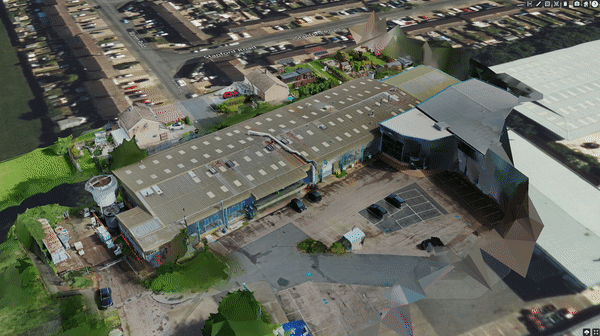
The Importance of Oblique Images in 3D Drone Mapping
In this post, we look at nadir + oblique images and why using them together is very important to create the best drone 3D Models possible.
Feb 24, 20233 min read


Are Building Regulations a call for Drones? | Hammer Missions
In this brief article, we will be looking at the current building regulations and how the use of drone technology can help accelerate change
Feb 21, 20233 min read


Accuracy of Stockpile Volumes from Drone images | Hammer Missions
In this study, we look at how accurate are the stockpile volume calculations from drone images, 3D models and hammer missions.
Jan 27, 20233 min read


How Do Drones & Digital Twins Power the Golden Thread of Information?
In this article, we will look at how do drones and digital twins power the golden thread of information in AEC.
Dec 22, 20225 min read


Accuracy of Measurements in Drone 3D Models | Hammer Missions
In this article, we understand the accuracy of 3D measurements using drone 3D models when compared to real world measurements.
Dec 21, 20222 min read


Drones In Construction | Hammer Missions Podcast
A podcast covering drones in construction, including everything from digital twins & measurements to integrations and stakeholder alignment
Nov 26, 20223 min read


Volumetric Measurements with Drone Data | Hammer Missions
In this article, we look at how to conduct Volumetric Measurements on Drone 3D models.
Nov 15, 20222 min read


Drone Mapping vs Drone Inspections | What's The Difference Anyway?
Drone Mapping vs Drone Inspection - What's the difference and when to use which? We answer the question in this post.
Nov 14, 20224 min read


How to 3D Map and Inspect a Building in the same project | Hammer Missions
This post explains how to 3D map and inspect a building in the same project using Hammer Hub, by Hammer Missions.
Nov 8, 20223 min read


Using Measurements in Hammer Missions | Drone Mapping
A step-by-step tutorial on how to make measurements (distances, areas, volumetric) using drone imagery and 3D models.
Nov 1, 20223 min read


Improving the Quality of your Drone Maps and 3D Models
In this post, we explore how you can greatly improve the quality of your drone maps and 3D models by focusing on key data capture workflows.
Oct 24, 20226 min read


The Role of Drones & Digital Twins in Engineering & Construction
Drones & Digital Twins are the most powerful thing to come to the AEC industries in decades.
Oct 19, 20226 min read


Drone Facade Mapping & Inspection - A step-by-step guide.
A guide to drone facade mapping and inspection using DJI drones and Hammer Missions.
Sep 6, 20226 min read


Camera Specs & Megapixels - Do they matter for Drone Photogrammetry?
A case study on drone camera megapixels and their impact on drone mapping and photogrammetry. Three 3D models were captured and processed.
Aug 30, 20228 min read


Drone Photogrammetry Software: How does it work under the hood?
Drone Mapping & Photogrammetry has become a common place. This guide looks at the steps involved in mapping and photogrammetry.
Aug 23, 20224 min read
Processing Drone 3D Models
Overview In this guide, we will look at how to create a 3D mapping workflow and the process of how you turn your captured data into a...
Jul 15, 20223 min read
bottom of page