
What is Vertical Overlap in Drone Mapping & Inspection?
- Hammer Missions

- Jul 10, 2025
- 3 min read
Understanding overlap is fundamental for anyone involved in drone mapping and inspections. Whether you're a seasoned professional or just starting out, you've likely heard about the importance of image overlap in creating accurate maps and 3D models.
But what exactly is vertical overlap, and why is it crucial for building inspections and complex 3D captures? Here, we'll show how mastering vertical overlap can enhance your drone inspection missions.

What Is Overlap in Drone Mapping?
Overlap is the shared area between two consecutive images captured by a drone during a mapping mission. This shared region is essential because it allows photogrammetry software to stitch images together seamlessly into a 2D map or 3D model. The more overlap you have, the easier it is for the software to identify common features and align images correctly.
Typically, drone operators aim for high overlap percentages (often 70% to 80%) to ensure data quality. But why is this overlap so critical? It all comes down to the fundamentals of photogrammetry.
Photogrammetry Simplified
Photogrammetry is the technique of using overlapping photographs to reconstruct the depth and dimensions of a scene, allowing the creation of detailed 3D models or accurate 2D maps.
The software looks for common features in overlapping images and uses these to calculate depth and spatial relationships. In simple terms, the greater the shared features between photos, the better the reconstruction.

What Is Vertical Overlap?
Vertical overlap refers to the shared areas between images taken above and below each other, which is especially important when inspecting vertical surfaces such as building facades.
When mapping horizontal surfaces like farms, quarries, or construction sites, only horizontal overlap matters because the drone’s camera points straight down. However, when inspecting buildings or facades, the drone’s camera must capture images from different heights and angles to ensure sufficient overlap vertically to enable accurate 3D reconstruction.
Applying Vertical Overlap in Facade Inspections
For facade inspections, you need to ensure that every image overlaps with those taken to the left, right, above, and below. This creates a grid of overlapping images covering the facade thoroughly, enabling the photogrammetry software to generate precise 3D models or 2D orthomaps of vertical surfaces.
If you're looking to improve the accuracy and efficiency of your building inspections, Hammer Missions can help. Our mission planning software is designed to support precise vertical and horizontal overlap for reliable 3D modelling. Schedule a call today:
Mapping Entire Buildings: Combining Horizontal and Vertical Overlap
When it comes to full 3D building mapping, things get a bit more complex. You have to consider:
Horizontal overlap for the roof
Vertical overlap for the facades
And critically, the overlap between the roof and the facades
This third overlap—the connection between horizontal and vertical image sets—is often overlooked and can cause stitching problems if not planned correctly.
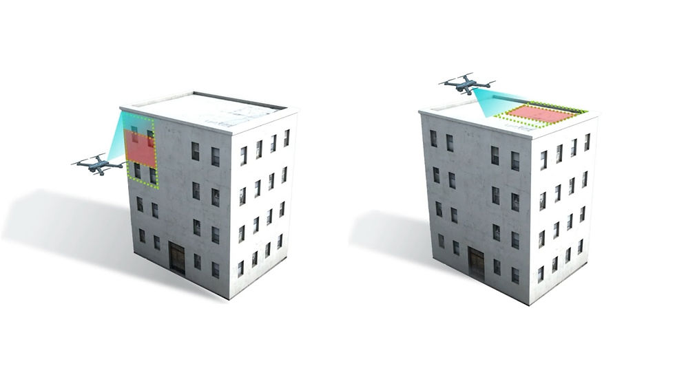
The Overlap Between Overlaps!
To capture this crucial shared region between the roof and facade, the drone’s camera should be angled obliquely. By adjusting the gimbal angle, you can capture images that include parts of both roof and facade, ensuring these two datasets connect seamlessly in the 3D model.
For example:
Use a camera angle of around -70° to capture the roof with some facade visible
Use an intermediate angle of about -45° to capture the shared regions between roof and facade
Use a 0° angle for capturing just the facade
This method guarantees that every image overlaps with adjacent images in all directions, creating a comprehensive dataset that results in a detailed and accurate full 3D building model.

Manual vs Automated Data Capture: Overlap Is Key
Even if you’re manually capturing data due to obstructions or safety considerations, the principles of overlap still apply. As long as each image overlaps sufficiently with images to its left, right, top, and bottom, you can reconstruct high-quality 3D models without relying solely on automated flight plans.
Looking Ahead: Planning Overlaps for Building Inspections
Mastering vertical overlap and the overlap between horizontal and vertical images is a game-changer for drone inspections, especially for complex structures like buildings. With these concepts in mind, you can plan missions that never fall short on data quality or stitching accuracy.
In further explorations, practical applications using tools like Hammer Missions software demonstrate how to plan roof inspections and facade inspections effectively, ensuring perfect overlap every time.
About Us
Hammer Missions is a software AI firm helping companies in the built environment leverage drones and AI for assessing existing conditions. Having seen 5000+ projects, we're pleased to be working with leading firms in AEC to streamline and scale the process of facade inspections. If you're looking to learn more about how AI can automate and accelerate your building assessment projects, please get in touch with us below. We look forward to hearing from you.

