What's New in Hammer Missions | July 2023 Product Update
- Hammer Missions

- Aug 3, 2023
- 2 min read
Updated: Aug 14, 2023
Hammer Hub 🖥
1. Flight Planning from Past Maps & 3D Models
They were never meant to be separate, and the industry needlessly divided them ⚡
Introducing...Flight planning using existing 3D models! 🌐 🚁
Now use your existing maps and models and overlay new flight plans on top to create highly detailed flight plans capturing every your job site from every possible angle!
✅ Generate High Quality Models
✅ Re-use existing Maps & Models
✅ Automate Detailed Capture
2. Snappier Measurements in 2D Maps
Introducing snappier 2D measurements in Hammer Missions! 🎉
✅ Now create 2D maps, measure distances, areas and more!
✅ Fine tune measurements while drawing.
✅ Easily copy out measurements into reports.
Check out 2D measurements in action on a roof job in the video below.
Snappier 3D measurements coming out soon!
3. 4D Models: Now available in our Cruise plan!
By using our new 4D timeline feature you can compare data you have collected over a period of time to check for anomalies, issues, or in the case of construction, track site progress.
This feature is now available on our Cruise plan.
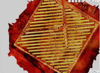
4. Solar Mission Improvements
We've improved the mission planning for our solar missions, including the correct GSD based on the chosen camera and the flight altitude. Moreover, you can now use an existing solar map to plan your more precise solar inspections on.

For more information, please see our post below which references a solar park that's not available on Google Maps.
5: Undo / Redo in Mission Planning
Made a mistake while mission planning? No issues, simply bring back or forward your edits by using the Ctrl + Z / Shift + Ctrl + Z keys.
1. Smooth Corners in Magnetic Mapping Missions
We've introduced smooth corners in our magnetic mapping missions. This helps in reducing pendulum swing for magnetometer-suspended missions.

To learn more about magnetic mapping missions, please visit:
2. Up / Down Flight Mode in Facade Inspection Missions
Capturing a tall building or structure? Now use the up and down mode in our facade mapping mission to fly the drone up and down first and then left-right.

3. M2EA, Mavic Pro 2 and M300 Health Diagnostics
Now use our health diagnostics feature to quickly identify and resolve aircraft issues on site. This is specially helpful for pre-flight checks and assessment before getting airborne.

4. Camera Footprint in Roof and Solar Missions
Capturing a roof or solar park? Now use our camera footprint feature to cross-check the camera foot print on the roof or the ground!

5. Data Verification version 2.0
Thrilled to share that our data verification capabilities are now available on all supported drones! Also, now use data verification capabilities in facade mapping, tower mapping and other vertical missions available in the Hammer App!
To learn more about data verification and why it is important, please visit:
Summary
And that’s it for this release! If you have any questions or would like to learn more about our enterprise solutions, don't hesitate to get in touch with us. We look forward to hearing from you.
- Team at Hammer Missions
team@hammermissions.com