
How Drones and CAD Are Converging to Create Smarter Assessment Workflows
- Hammer Missions

- Apr 29
- 8 min read
Updated: May 6

The engineering and asset management world has spent years building its digital foundation — adopting CAD and BIM to replace paper drawings, moving to cloud collaboration to break down silos, and implementing structured data platforms to improve inspection coordination. But one critical gap has remained: the link between the designed model and the real, physical condition of structures in the field.
That gap is closing. And drones are how it's happening.
The convergence of UAV data capture with CAD and BIM workflows is fundamentally changing how engineers, inspectors, and asset owners assess, document, and manage their built environment. For teams still treating drone surveys and CAD models as separate tools, this piece is a practical look at why that approach is becoming a competitive disadvantage — and what a fully integrated drone-CAD workflow actually looks like across facades, bridges, buildings, and parking structures.
The Problem with Traditional Inspection Data

A CAD or BIM model is only as useful as the data feeding it. The challenge for most inspection and asset management teams has always been the same: design information is digital, precise, and structured — but condition data is captured slowly, manually, and sporadically.
By the time a defect or deviation is discovered and documented, it has often progressed well beyond its earliest detectable stage. Whether it's spalling on a bridge soffit, sealant failure on a building facade, or surface cracking in a parking deck, issues flagged late become exponentially more expensive to remediate.
The traditional access-based approach to inspection — scaffolding, cherry pickers, rope access — is slow, expensive, and produces data formats that don't integrate neatly with modern CAD and BIM environments. Something had to change.
What Drones Bring to the CAD Workflow

The fundamental value of drones in a CAD context isn't just that they capture inspection data faster — it's that they capture it in a format that feeds directly into the model.
A single drone flight can capture detailed imagery and geometric data that would traditionally require days of access rigging and manual survey work. That speed allows for regular, repeatable condition assessments, ensuring the digital model remains a true reflection of the asset's current state.
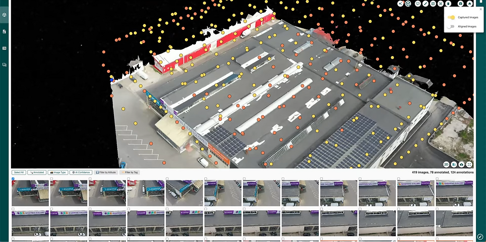
The data formats that come out of a drone survey — point clouds, orthomosaics, 3D photogrammetric models — are natively compatible with the platforms engineering teams already use. Drone-generated outputs integrate directly with CAD environments, and data fed into modelling tools is used to update detailed 3D models that give asset owners and engineers real-time insight into structural conditions.
The result is a model that doesn't just represent design intent — it represents what's actually there, updated continuously throughout the asset's lifecycle.
From Static Model to Living Digital Twin
This is where the drone-CAD convergence moves from efficiency gain to something more transformational: the creation of a genuine digital twin.
Unlike a traditional CAD drawing or BIM file, a digital twin does not represent design intent alone — it reflects how an asset actually exists and performs in the real world, based on real-time and historical condition data. The CAD model is the starting point; the digital twin is its operational evolution, kept current through continuous data capture.
Reality capture technologies such as drones and photogrammetry are now routinely integrated into BIM and CAD workflows to validate existing conditions, track deterioration over time, and generate accurate as-inspected models. Continuous validation helps reduce the gap between assumed and actual structural conditions — especially on ageing infrastructure and high-value assets with complex facades.
Industry surveys conducted in 2025–2026 reveal that approximately 52% of AEC and asset management leaders are implementing digital twins, rising to nearly 67% among owners and facilities managers focused on operational efficiency — a clear signal that this is no longer an experimental approach but a mainstream operational practice.
💡 Enjoying these insights? Subscribe to the Hammer Missions newsletter for expert tips, real-world drone inspection case studies, and the latest updates on how AI is transforming building assessments:
The Practical Workflow: How Integration Actually Works
Understanding the concept is one thing. Understanding the workflow is another. In a well-integrated drone-CAD inspection pipeline, the process typically follows four stages.
1. Baseline condition capture Before an active maintenance programme begins, a drone survey establishes existing conditions across the entire structure — surface geometry, visible defects, material condition. This data establishes a georeferenced baseline in the CAD model, against which all future inspections are compared.
2. Periodic condition monitoring Regular drone surveys at defined intervals capture updated condition data, which is overlaid on the existing CAD model to identify new defects, track the progression of known issues, and quantify rates of deterioration. Where traditional inspection relied on subjective written reports, drone-CAD integration produces a visual, quantifiable record of how an asset is changing over time.
3. Defect mapping and engineering assessment Drone imagery — processed through AI-powered defect detection — is mapped directly onto the CAD model, with each defect georeferenced to its precise location on the structure. Engineers can query the model to understand defect distribution, identify areas of concentrated deterioration, and prioritise remedial works with a level of confidence that anecdotal inspection reports cannot provide.
4. Ongoing lifecycle documentation The drone-maintained CAD model becomes a permanent, continuously updated record of the asset's condition history — a foundation for maintenance planning, insurance documentation, regulatory compliance, and capital investment decisions that a folder of PDFs and inspection photos simply cannot replicate.
The Structures That Benefit Most
Drone-CAD integration delivers measurable value across a range of structure types, each with its own inspection challenges.
Facades
Building facades present one of the most complex inspection challenges in the built environment — large surface areas, varied material types, and defects that can be invisible from ground level. Drone surveys paired with AI-powered defect detection allow inspectors to capture the entire envelope systematically, identifying cracks, delamination, staining, sealant failure, and moisture ingress at a resolution that simply isn't achievable through visual inspection alone. When mapped directly onto the facade's CAD model, defect data is precisely georeferenced, giving engineers and maintenance teams an accurate, queryable record of condition across every elevation.
Bridges
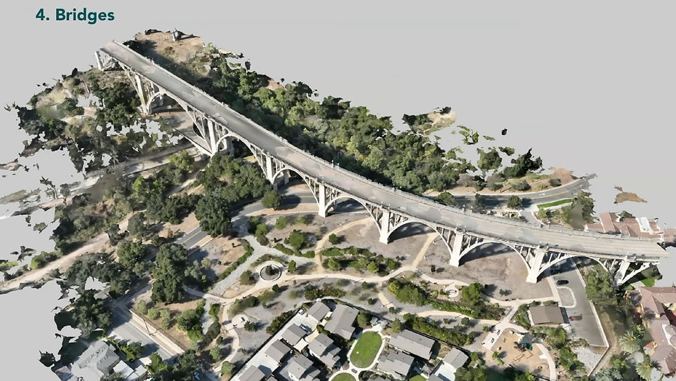
Bridge inspection has historically been one of the most logistically demanding tasks in civil infrastructure — requiring lane closures, specialist access equipment, and significant mobilisation costs. Drones change the access equation entirely. Soffits, pier faces, expansion joints, and bearing areas can all be captured in detail without putting inspectors in difficult or dangerous positions. Point cloud data from drone surveys integrates directly with existing bridge models, enabling quantitative comparison between original design geometry and current structural form — critical for identifying deflection, settlement, or section loss that traditional visual inspection would miss.
Buildings and Commercial Structures
For multi-storey commercial buildings, drone surveys provide a repeatable, cost-effective basis for periodic condition assessments of roofs, parapets, cladding systems, and external M&E plant. Captured data overlaid on the building's BIM or CAD model gives facilities teams and building engineers a structured framework for prioritising maintenance, managing warranty claims, and planning capital expenditure — replacing ad hoc inspections with a systematic, data-driven approach.
Parking Structures
Parking decks and multi-storey car parks are among the most maintenance-intensive assets in the built environment. Exposed concrete, de-icing salts, and heavy repetitive loading create conditions where carbonation, chloride ingress, and rebar corrosion can progress rapidly if not caught early. Drone surveys of parking structure soffits, columns, and deck surfaces — feeding condition data into a georeferenced CAD model — allow engineers to track deterioration trends over time, target intrusive investigation precisely, and build defensible maintenance programmes backed by documented evidence.
The Impact on Stakeholder Communication

One of the less-discussed but highly significant benefits of drone-CAD integration is what it does for client and stakeholder communication. Structural condition is notoriously complex to communicate — particularly to building owners and asset managers who don't have a technical background.
A navigable, regularly updated 3D model of a structure's condition changes that dynamic entirely. Instead of reviewing written reports and annotated photographs, owners can see the actual state of their asset at any point in time, understand exactly where defects are located, and make informed decisions about maintenance priorities and budget allocation.
Research published in 2025 found that BIM adoption reduces project timelines by an average of 20% and costs by 15%, while decreasing documentation errors significantly — with BIM enhancing collaboration among stakeholders and facilitating better risk assessment throughout the asset lifecycle. When drone condition data is feeding that model continuously, those benefits compound across inspection programmes as well as construction projects.
Beyond Construction: The Ongoing Inspection and Maintenance Case

The drone-CAD integration story doesn't end at handover. For building owners, AEC firms involved in building science, and facilities management teams, the as-built digital twin becomes the foundation for an entirely different kind of value: lifecycle asset management.
CAD doesn't stop at construction — infrastructure managers can use it to plan maintenance, track the evolution of a structure, detect anomalies, and assess the impact of future projects. Periodic drone surveys of the building envelope, feeding updated data back into the model, create a 4D record of how the asset changes over time — a powerful tool for predictive maintenance, insurance documentation, and capital planning.
For building envelope specialists in particular, this integration enables a level of condition monitoring that was previously impossible at scale. AI-powered defect detection applied to drone imagery — identifying cracks, corrosion, spalling, sealant failure, and moisture ingress — can be mapped directly to the building's CAD model, giving maintenance teams and engineers precise, georeferenced data on where problems are occurring and how they're developing over time.
What Effective Integration Requires
Recognising the value of drone-CAD integration is the easy part. Actually implementing it effectively requires attention to a few key areas:
Data quality and georeferencing precision
The drone survey data is only as useful as its accuracy. Sub-centimetre georeferencing is achievable with RTK-enabled drone hardware, but requires proper ground control point placement and calibrated workflows. Errors at the data capture stage propagate through every downstream use of the model.
Standardised data protocols
Reality capture combined with CAD helps teams maintain alignment between design models and on-site conditions throughout the project lifecycle, but only when data is captured and formatted consistently. Teams need standardised flight plans, consistent capture intervals, and agreed file formats to ensure outputs integrate cleanly with the CAD environment.
The right software pipeline
Drones and LiDAR are now default tools for as-built modelling, with point cloud processing used to build accurate models from scan data, reducing rework. The processing software that sits between the drone and the CAD platform — converting raw imagery into point clouds, orthomosaics, and 3D models — is a critical part of the chain. Platforms that automate this processing and integrate directly with CAD environments reduce friction and the risk of data loss between steps.
A single workflow, not multiple tools
One of the most common failure points in drone-CAD integration is the fragmentation of the software stack — separate tools for flight planning, data processing, model analysis, defect annotation, and reporting that don't speak to each other. The efficiency gains of integration are quickly eroded when teams are manually transferring files between disconnected platforms.
How Hammer Missions Supports the Drone-CAD Workflow

Hammer Missions is designed around the principle that drone data capture and intelligent analysis should exist in a single, connected workflow — not across a fragmented set of tools. From automated 3D flight planning across 15+ mission types to AI-powered defect detection via Spector AI, precise annotation and measurement on 3D models, and structured report generation, the platform is built to produce the kind of high-quality, actionable deliverables that integrate directly into AEC and building management workflows.
Whether you're capturing a building envelope for as-built documentation, monitoring construction progress against a design model, or conducting periodic facade and roof inspections for maintenance planning, Hammer Missions gives your team the data quality and workflow efficiency that a serious drone-CAD integration demands.
Interested in learning more about drone-based facade inspections or seeing how AI can enhance your workflows? Reach out to the Hammer Missions team — we’d love to show you how to bring this process to your next project.
About Us
Hammer Missions is a software AI firm helping companies in the built environment leverage drones and AI for assessing existing conditions. Having seen 5000+ projects, we're pleased to be working with leading firms in AEC to streamline and scale the process of facade inspections. If you're looking to learn more about how AI can automate and accelerate your building assessment projects, please get in touch with us below. We look forward to hearing from you.


