

Engineering & Building Science

Drone Inspections
Smarter, Safer,
& More Accurate
Engineering firms are under pressure to deliver faster, safer, and more detailed assessments. With modern drone inspections, consultants can cover nearly 100% of a roof or façade, reduce reliance on rope access, and improve accuracy in defect detection.
Hammer Missions' drone inspection software empowers structural engineers to quantify deficiencies, streamline reporting, and provide clear, data-driven insights to clients.
How Drones Assist Your Workflows
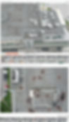
Asset Cover
Traditional visual checks often capture just ~25% of a façade or roof. With drone roof inspections and drone assisted roof inspection software, engineers can document nearly 100% of the building envelope — ensuring no critical defects are missed.
Drop Planning
If physical rope-access or lift-based checks are still required, drone utility inspections highlight exactly where to focus. Engineers can plan drop locations and inspection priorities with high confidence, reducing unnecessary risk and time on site.
Quantification & Reporting
Our drone roof inspection software uses AI to automatically detect and quantify deficiencies such as cracks, sealant failures, or spalling. Images are auto-tagged and reports are auto-generated, helping engineering firms cut turnaround times while delivering detailed, defensible results.


AI-Powered Drone Inspections
AI elevates drone inspection services by turning imagery into actionable insights. In a drone roof inspection or drone utility inspection, the software analyses data and tags defects.
For consultants and engineers, this means less time reviewing images and more time making critical decisions.
Our drone inspection software, Spector AI, detects faults from cracks and corrosion to water ingress and spalling. This enables engineering firms to deliver faster, more accurate assessments while maintaining safety and compliance.
How it Works
Step 1:
Capture your Footage
Capture drone footage of your project using an in-house pilot or a our drone service provider partners.

Step 2:
Upload & Create 3D Models
Easily upload your drone footage to our secure cloud-based platform. Our system automatically organises, processes, and prepares your data for 3D modelling and analysis

Step 3:
Analyse with AI & Generate Reports
Our advanced Spector AI model helps you to detect anomalies, classify defects, and generate actionable reports in a fraction of the time. Make informed maintenance decisions — all in one dashboard.

Frequently Asked Questions
Hear It from Our Customers

"Hammer Missions takes the complexity of photogrammetry and streamlines it to be simple for engineers and asset owners alike. The AI defect detection removes the headache of sifting through thousands of photos, saving everyone time and effort"
- Nicholas Zeeb, President at ZeeDrone Aerial Solutions


